Antigua and Barbuda
Antigua and Barbuda (Spanish for "Ancient" and "Bearded") is an island nation located on the eastern boundary of the Caribbean Sea with the Atlantic Ocean. It consists of two major islands – Antigua (pronounced /ænˈtiːɡə/) and Barbuda (/bɑrˈbjuːdə/) – and a number of smaller islets. All are close neighbors within the middle of the Leeward Islands, and are located roughly 17 degrees north of the equator.
Antigua has a population of 82,000, comprising chiefly a mixture of people of West African, British, and Portuguese descent. The islands of Antigua and Barbuda are part of the Lesser Antilles archipelago. To the south of Antigua and Barbuda lie the islands of Guadeloupe, Dominica, Martinique, Saint Lucia, Saint Vincent and the Grenadines, Barbados, Grenada, and Trinidad and Tobago. Montserrat lies to the southwest; Saint Kitts and Nevis and Saint Eustatius are to the west, and Saint Barthélemy, Saint Martin and Anguilla are to the northwest.
History
Antigua was first settled by pre-agricultural Amerindians known as "Archaic People", commonly referred to as Ciboney, which means "stone people" in Arawakan. The earliest settlements on the island date to 2900 BC. They were succeeded by ceramic-using agriculturalist Saladoid people who migrated up the island chain from Venezuela. They were later replaced by Arawakan speakers, and around 1500 [BC?] by Island Caribs.
The Arawaks were the first well-documented group of Antiguans. The Arawaks called Antigua Wadadli, which means land of oil, perhaps a reference to eucalyptus oil extracted from eucalyptus trees. They paddled to the island by canoe (piragua) from Venezuela, ejected by the Caribs—another people indigenous to the area. Arawaks introduced agriculture to Antigua and Barbuda, raising, among other crops, the famous Antiguan "Black" pineapple. They also cultivated various other foods including corn, sweet potatoes (white with firmer flesh than the bright orange "sweet potato" used in the United States), chiles, guava, tobacco and cotton.
The bulk of the Arawaks left Antigua about 1100 A.D. Those who remained were subsequently raided by the Caribs. According to the Catholic Encyclopedia, the Carib's superior weapons and seafaring prowess allowed them to defeat most Arawak nations in the West Indies—enslaving some, and possibly cannibalizing others (though this is unclear because many sources dispute the fact that Indian societies cannibalised each other).
The Catholic Encyclopedia does make it clear that the European invaders had some difficulty identifying and differentiating between the various native peoples they encountered. As a result, the number and types of ethnic/tribal/national groups in existence at the time may be much more varied and numerous than the two mentioned in this Article.
According to A Brief History of the Caribbean (Jan Rogozinski, Penguin Putnam, Inc September 2000 ), European and African diseases, malnutrition and slavery eventually destroyed the vast majority of the Caribbean's native population. No researcher has conclusively proven any of these causes as the real reason for the destruction of West Indian natives. In fact, some historians believe that the psychological stress of slavery may also have played a part in the massive number of native deaths while in servitude. Others believe that the reportedly abundant, but starchy, low-protein diet may have contributed to severe malnutrition of the "Indians" who were used to a diet fortified with protein from sea-life.
The indigenous West Indians made excellent sea vessels that they used to sail the Atlantic and Caribbean. As a result, Caribs and Arawaks populated much of South American and the Caribbean Islands. Relatives of the Antiguan Arawaks and Caribs still live in various countries in South America, notably Brazil, Venezuela and Colombia. The smaller remaining native populations in the West Indies maintain a pride in their heritage.
The island of Antigua was named Wadadli by these natives and is today called "Land of Wadadli" by locals. Christopher Columbus landed on his second trip in 1493 and named the island Santa Maria de la Antigua after an icon in Seville Cathedral, Spain. Early settlement by the Spanish was replaced by English rule from 1632 (British rule from 1707 Acts of Union), with a French interlude in 1666. Slavery, established to run the sugar plantations on Antigua, was abolished in 1834.
The islands became an independent state within the Commonwealth of Nations on November 1, 1981, with Elizabeth II as the first Queen of Antigua and Barbuda and the Right Honourable Vere Cornwall Bird became the first prime minister.
Geography of Antigua and Barbuda
Antigua and Barbuda lie in the eastern arc of the Leeward Islands of the Lesser Antilles, separating the Atlantic Ocean from the Caribbean Sea. Antigua is 650 km southeast of Puerto Rico; Barbuda lies 48 km due north of Antigua, and the uninhabited island of Redonda is 56 km southwest of Antigua. The largest island, Antigua, is 21 km (about a dozen miles) across and 281 km² (about a hundred square miles) in area, or about two-thirds the size of New York City, seven eighths the area of Inner London or 86% greater than the London Borough of Bromley. Barbuda covers 161 km² (about 5% more than Bromley), while Redonda encompasses a mere 2.6 km² making it comparable to The City of London, about 1 square mile (3 km2). The capital of Antigua and Barbuda is St. John's, located at St. John's Harbour on the northwest coast of Antigua. The principal city of Barbuda is Codrington, located on Codrington Lagoon.
Mountains and Hills
Antigua and Barbuda both are generally low-lying islands whose terrain has been influenced more by limestone formations than volcanic activity. The highest point on Antigua, however, is Mount Obama (formerly Boggy Peak), the remnant of a volcanic crater rising 399 metres. This mountain is located amid a bulge of hills of volcanic origin in the southwestern part of the island. The limestone formations in the northeast are separated from the southwestern volcanic area by a central plain of clay formations. Barbuda's highest elevation is 44.5 metres, part of the highland plateau east of Codrington. The shorelines of both islands are greatly indented, with beaches, lagoons, and natural harbours. The islands are rimmed by reefs and shoals. There are few streams, as rainfall is slight. Both islands lack adequate amounts of fresh groundwater. Redonda has no significant elevation.
Neither Barbuda nor Redonda have any significant elevations.
Oficial Name:
Antigua and Barbuda
Independence:
November 1, 1981
Area:
442km2
Inhabitants:
79.000
Language:
Antigua and Barbuda Creole English [aig] 66,970 in Antigua and Barbuda (2001). Population total all countries: 125,244. Spoken throughout Antigua and Barbuda . Also spoken in Anguilla, Dominica, Montserrat, Saint Kitts and Nevis, United Kingdom. Alternate names: Leeward Caribbean Creole English. Dialects: Antiguan Creole English, Barbuda Creole English. Slightly intelligible with Jamaican and perhaps Bahamas creoles. May be close to English Creoles of the Virgin Islands and Netherlands Antilles. There is a creole continuum with Standard English. Classification: Creole, English based, Atlantic, Eastern, Southern
English [eng] Classification: Indo-European, Germanic, West, English
Capital city:
St.Jonh's
Meaning of the country name:
Christopher Columbus named Antigua in honour of the Santa María La Antigua ("Saint Mary the Old") cathedral in Seville, Spain when he landed there in 1493. "Barbuda" means "bearded" in Portuguese. The islands gained this name after the appearance of the their fig trees, whose long roots resemble beards. Alternatively, it may refer to the beards of the indigenous people.
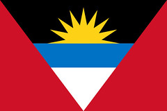
Description Flag:
The national flag of Antigua and Barbuda was adopted on February 27, 1967, and was designed by a school teacher named Reginald Samuels. The sun symbolises the dawning of a new era. The colours have different meanings, the black is for the African ancestry of the people, the blue for hope, the red for energy. The successive colouring of yellow, blue, and white (from the sun down) also stands for the sun, sea, and sand.
Coat of arms:
The coat of arms of Antigua and Barbuda was designed in 1966 by Gordon Christopher. It was officially introduced on 16 February, 1967. The symbolism of the arms is more complex than that found on the Flag of Antigua and Barbuda, but many elements are similar.
At the top of the Coat of Arms is a pineapple, a fruit for which the islands are famous. There are several plants found around the shield, all abundant in the country: red hibiscus, sugarcane, and yucca plant. Supporting the shield is a pair of deer representing the wildlife of the islands.
The design on the shield shows the sun, also found on the flag, rising from a blue and white sea. The sun symbolises a new beginning, and the black background represents the African origins of many of the nations's citizens. At the bottom of the shield, in front of the sea, sits a stylised sugar mill.
At the bottom is a scroll upon which is written the national motto: "Each endeavouring, all achieving".
Motto:
"Each Endeavouring, All Achieving"
National Anthem: Fair Antigua, We Salute You
Fair Antigua and Barbuda!
We thy sons and daughters stand
Strong and firm in peace or danger
To safeguard our Native Land
We commit ourselves to building
A true nation brave and free;
Ever striving, ever seeking,
Dwell in love and unity
Raise the standard! Raise it boldly!
Answer now to duty's call
To the service of thy country,
Sparing nothing, giving all;
Gird your loins and join the battle
'Gainst fear, hate and poverty,
Each endeavouring, all achieving,
Live in peace where man is free.
God of nations, let Thy blessings
Fall upon this land of ours;
Rain and sunshine ever sending,
Fill her fields with crops and flowers;
We her children do implore Thee,
Give us strength, faith, loyalty,
Never failing, all enduring
To defend her liberty.